|
�@�O���C�g�E�T���h�E�f���[���Y
- �卻�u�����������ی�n�� - ���X�J�A�R�����h USA
�����j
 �l�Ƃ̊W �l�Ƃ̊W
���ꎩ�g�S�̂̓��ƂȂ�l�͂��Ȃ��G�l�͂��ꂼ��嗤�̈�Ђł���B���̎�̂̈ꕔ .... �N���̎������������Ă����B����͎����l�ނɊ܂܂�Ă��邩��G�����Ă���䂦�ɒN�̂��߂Ƀx�����H������̂��m�낤�Ƃ��܂��G����͓��̂��߂ɖ�̂�����B
�W�����E�_��
�l�ƍ��u�F
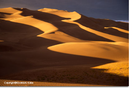
�i�E�ʐ^�FMosca Pass Toll Stateion: Courtesy of Great Sand Dunes
National Park & Preserve�j
�i�v�I�ȂȂ���l�͂��̑��݂�m���Ă������A�K�₵�A�����đ卻�u�̋߂��ɒ����ԏZ��ł��܂����B�m���Ă���ŌÂ̐l�ނ̑��݂�11,000�N�قǑO�ɂȂ�܂��B
�������ێ�����F11,000�N�O�̌��n�l��
�T������C�X��o���[�Ƒ卻�u�n��ɑ��ݓ��ꂽ�ŏ��̐l�X�͗V�q����ł����B�t�߂ɐ������W�܂��Ă����}�����X��L�j�ȑO�̃o�C�\���̌Q����͂ނ悤�ɏW�܂��Ă����ƍl�����܂��B�ނ�͐Ί펞��l�ŁA���݃N���r�X
Clovis �ƃt�H���T�� Folsom ��[�ƌĂ�Ă���A�傫�ȐΓ����܂��͓��������g���Ď�����Ă��܂����B�قƂ�Ǒ��̒N���Ɠ����悤��400�N�قǑO�ɂȂ�܂ł́A�l�̓T���E���C�X�E�o���[�ɕ����ē����Ă��܂����B���A���̎悪�悩�������ɂ����Ŏ����߂����A����H�Ɠ�̎��͂��̒n�������Ă����̂͊m���Ȃ悤�ł��B
�����̂Ȃ���F ����A�����J�C���f�B�A��
�����̐l�X���ǂ̂悤�Ȗ��O�̌�����g���Ă��̂��͕���܂��A����̃A�����J�C���f�B�A���̎푰�̓X�y�C���l����400�N�O�ɂ��̒n�Ɏn�߂đ��ݓ��ꂽ���ɂ��̒n�Ɋ���e����ł��܂����B�`���I�ȃ��[�g����ő卻�u��
sowapophe-uvehe �ƌ����܂��B�u�O�Ɍ�ɓ����y�n�v�Ƃ����Ӗ��ł��B�q�J���[�A���A�p�b�`�͖k���j���[���L�V�R�ɒ�Z���卻�u��
ei-anyedi �u����͏㉺�ɓ����v�ƌĂт܂����B�卻�u�̂�������ނ���u�����J��s�[�N (Blanca Peak
�W����4,303�b�j�̓i�o�z�������Ȃ�R�Ǝ]����S�̎R�̈�ł��B�����̐l�X�̉ߋ��ƌ��݂̂Ȃ���Ƃ͉��Ȃ̂ł��傤�H
�q�J���[�A���A�p�b�`�Ɠ샆�[�g���ɂƂ��āA����͌����I�Ȗ��ł��B�ނ�̓T���E���C�X�E�o���[�Ŗ�h����������̂ł��B�ނ炪���u�ɂ������A�H�p�����Ė�p�Ƃ��Ďg���Ă����|���f���[�T�p�C��
Ponderosa pine �̖X��������̕\��w���W�߂Ă��܂����B���I�E�O�����f�ɉ������n��ɏZ��ł����e��/�e�B��
Tewa/Tiwa ���b���v�G�u�������炫���l�X�ɂƂ��ẮA����Ƃ̃����N�������̂ł����B�ނ�͂��̍��u�ߗׂ̃T���E���C�X�E�o���[�Ɉʒu����A�ނ炪�����Ɍ����鎞�ɒʂ蔲���Ă��̂���Ƃ�����A�傫�ȏd�v�������`���I�Ȉ�Ղ��L�����Ă��܂��B
�u�����̓��[�g�����ȑO�悭�W�܂��Ă����ꏊ�̂ЂƂł����B...
�L���v���^ Capulta ��c�͂��̒n��ŃL�����v���������A���ł����B�ߏ��̉Ƒ������͂����ɗ��Ĕނ�ƈꏏ�ɃL�����v�����̂����H���Ԃ�t�̏��߂��H���[�܂������������ł��傤�B���[�g���͈��ړI�A�����ĐH�����Ƃ��āA�|���f���T�p�C������\����g���Ă��܂����B....
�����̕�������Ĉ��������Ă����̂ł��傤�B��������Ď��n���Ă��܂����B����N��ɂȂ�܂ł́A�Ⴂ�q�ǂ���������`���܂������A��{�I�Ɏ�����̎��n�͏������̎d���Ŕޏ��������X��I��ł��܂����B....
�v
�A���f���E�i�����S Alden Narango�A�샆�[�g�����j��
�X�y�C���l�ɂ��T���F
Don Diego de Vargas, 1694
Juan Bautista de Anza, 1776
���݂̖k���j���[���L�V�R�B�ɂ������X�y�C���A���n����q�v���l�����炭�������1598�N���ɂ͂��̒n�ɓ����Ă����ł��傤���A1694�N�Ƀh���E�f�B�G�S�E�f�E�o���K�X
Don Diego de Vargas ���T���E���C�X�E�o���[�ɓ��������ƂŒm����ŏ��̃��[���b�p�l�ƂȂ�܂����B�f�E�o���K�X�Ɣނ̕��������͂ǂ����o���[�암�ŁA�T���^�E�t�F�ɖ߂�O�ɁA�o�C�\�����݂��Q���500����������悤�ł��B
 1776�N�ɂ́A�R�}���`���̈�R�ɕU������������̋A�蓹�ɁA���A���E�o�E�e�B�X�^�E�f�E�A���U�ƂƂĂ��Ȃ������̑��߂������ƒ{���āA���炭���̍��u�̋߂���ʂ����悤�ł��B���̍��̃T���E���C�X�E�o���[�́A�R�}���`���A���[�g���A�����ăX�y�C���������ɂƂ��āA�����n�тƃT���^�t�F�̊Ԃ̗��s���[�g�ł����B�ł�����A�ނ�̑����ɂƂ��ăg���[�����猩���鍻�u��������ׂɂȂ��Ă������Ƃł��傤�B 1776�N�ɂ́A�R�}���`���̈�R�ɕU������������̋A�蓹�ɁA���A���E�o�E�e�B�X�^�E�f�E�A���U�ƂƂĂ��Ȃ������̑��߂������ƒ{���āA���炭���̍��u�̋߂���ʂ����悤�ł��B���̍��̃T���E���C�X�E�o���[�́A�R�}���`���A���[�g���A�����ăX�y�C���������ɂƂ��āA�����n�тƃT���^�t�F�̊Ԃ̗��s���[�g�ł����B�ł�����A�ނ�̑����ɂƂ��ăg���[�����猩���鍻�u��������ׂɂȂ��Ă������Ƃł��傤�B
���ւ̊g���F
Zebulon Pike, 1807
�[�u�����E�p�C�N��1807�N�̎�L�ɏ�����Ă��鍻�u�Ɋւ���L�q�͋��炭�m���Ă���ŏ��̏��ʂł��傤�B���C�X�E�A���h�E�N���[�N�T�����͓��ɖ߂��čs�������ɁA�p�C�N�č����R���т͉����̓A�[�����T�[��b�h����o�[�Ɏ���قǂ̉����܂ł̒T���𖽂����Ă��܂����B1806�N11�����܂łɃp�C�N�Ɣނ̕��������͍����̃R�����h�B�v�G�u����������Ƃ���܂ő���i�߂Ă��܂��B����ɓ쐼�Ɍ������A�������Ȃ���A�[�J���T�[��̈ʒu��c���ł����������Ȃ���A�p�C�N�͒��x�卻�u�̏�̂�����̃T���O����f��N���X�g�R�����z���Ă��܂����B�ނ�1807�N1��28���̎�L�ɂ��ƁF
�u���}�C���s�i��������ɁA��X�͔�������....�����R�X�̘[�Ɂi�����̃T���O���E�f�E�N���X�g�R���j�����������čs���ƁA���̋u��������....�L�����v���͂荻�u�Q�̒��̍ł��������̂ɓo���Ă݂��B����Ɩ]�����������đ傫�Ȑ�i���I�E�O�����f�j�����邱�Ƃ��ł����B....���̋u�͏�艺�肵�Ĕ����R���Q�̘[�ɉ�������Ă���̂��������B����͂P�T�}�C�����炢�����ĕ��͂T�}�C�����炢�Ɍ������B�����͐F�����Ⴆ�A�����̏�ɂ͐A���̈�l�����Ȃ��A���x�C�ōr��闒�̒��̔g�̂悤�Ɍ������B�v
John C. Fremont, 1848
John Gunnison, 1853
1848�N��
1n 1848, John C. Freemont
was hired to find a railroad route from St. Louis to California.
He crossed the Sangre de Cristos in the San Luis Valley in
winter, courting disaster but proving that a winter crossing
of this range was possible. He was followed in 1853 by Captain
John Gunnison of the U.S. Topographical Survey. Gunnison's
party crossed the dunefield on horseback: "Touring the
southern base of the sand-hills, over the lowest of which
we rode for a short distance, our horses half burying their
hoofs only on the windward slopes, but sinking to their knees
on the opposite, we for some distance followed the bed of
the stream from the pass, now sunk in the sand, and then struck
off across the sandy plain�cThe sand was so heavy that we were
six hours and a half making ten miles�c"
Routes into the Valley
In the years that followed,
the Rockies were gradually explored, treaties were signed
and broken with resident tribes, and people with widely differing
goals flooded into Colorado from the United States and Mexico.
In 1852, Fort Massachusetts was built and then relocated to
Fort Garland, about 20 miles southeast of the Great Sand Dunes,
to safeguard travel or settlers following the explorers into
the San Luis Valley.
Although many settlers arrived
in the San Luis Valley via the trails from Santa Fe or La
Veta Pass, several routes over the Sangre de Cristo Mountains
into the San Luis Valley were well-known to American Indians
and increasingly used by settlers in the 1800s. Medano Pass,
also known as Sand Hill pass, and Mosca Pass, also called
Robidoux's Pass, offered more direct routes form the growing
front-range cities and dropped into the San Luis Valley just
east of the Great Sand Dunes. Trails were improved into wagon
routes and eventually into rough roads. The Mosca Pass Toll
Road was developed in the 1870s, and stages and the mail route
used it regularly through about 1911. That year, the western
portion was badly damaged in a flash flood. Partially rebuilt
at times in the 1930s through the 1950s, it has been repeatedly
closed by flooding and is now a trail for hikers.
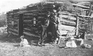
Making a Home: Homesteaders
Homesteader Ulysses Herard,
who with his family established a ranch and homestead along
Medano Creek in 1875, would have used the old Medano Pass
Road to travel to and from his home. The modern road, open
only to 4WD, high clearance vehicles, follows the old route,
skirting the dunefield before rising to Medano Pass and continuing
east into the Wet Mountain Valley. The Herards grazed and
bred livestock in the mountain meadows, built a home, raised
horses, cattle, and chickens, and established a trout hatchery
in the stream.
Other families homesteaded
near the Dunes as well, including the Teofilo Trujillo family,
who raised sheep west of the Dunes. And Frank and Virginia
Wellington, who built the cabin and hand-dug the irrigation
ditch that parallels Wellington Ditch Trail, just south of
today's campground. Their son, Charles, ran a sawmill on Sawmill
Creek, just north of the campground.
As people established homes,
they often petitioned the U.S. Postal Department for post
offices to serve their tiny villages. Zapata (1879); Blanca
or North Arrastre; Orean (1881); Mosco (1880); later called
Montville (1887-1900); Herard (1905); Liberty (1900); Duncan
(1892) and others helped connect isolated homesteaders with
the larger world.
Seeking Wealth: The Gold Rush, 1853 and later
Gold and silver rushes occurred
around the Rockies after 1853, bringing miners by the thousands
into the state and stimulating mining businesses that operate
to this day. Numerous small strikes occurred in the mountains
around the San Luis Valley. People had frequently speculated
that gold might be present in the Great Sand Dunes, and in
the 1920s, local newspapers ran articles estimating its worth
at anywhere from 17 cents/ton to $3/ton. Active placer mining
operations sprang up along Medano Creek, and in 1932 the Volcanic
Mining Company established a gold mill designed to recover
gold from the sand. Although minute quantities of gold were
recovered, the technique was too labor-intensive, the stream
was too seasonal, and the payout was too small to support
any business for long.
Preserving the Beauty: Establishing a National Park Service
Site
The idea that the Dunes could
be destroyed by gold mining or concrete-making alarmed residents
of Alamosa and Monte Vista. By the 1920s, the Dunes had become
a source of pride for local people and a potential source
of tourist dollars for local businesses.
Members of the Ladies PEO
sponsored a bill to Congress asking for national monument
status for the Great Sand Dunes. Widely supported by local
businesses and Chanbers of Commerce, the bill was signed into
law in 1932 by President Herbert Hoover.
Living at the Dunes
Imagine: you are standing on the edge of a shallow lake, surrounded
by cattails and birdsong. The dunes hover on the horizon to
the north. You're carrying a small fiber pouch filled with
sharp flakes of stone, and you're wearing very little-to what
time do you belong? Or again, it's a summer day and you're
bridling your horse at Montville, Colorado and listening to
the flies buzz. You wear the blue and gold of a cavalryman.
When and where are you? And once again: you're digging a shallow
pit in the side of an old grass-covered dune. Carefully you
photograph the layers of different colored sandy soils you
observe before digging deeper. What are you doing-and why?
Students in the future may
be able to identify all three of the characters sketched above
as people who lived part of their lives at the Great Sand
Dunes, thanks to a four-year research project that began summer
2000. "This is a pretty neat project," states Resource
Specialist Fred Bunch. "It's really a chance to look
at all kinds of different reasons that all kinds of different
people visited the dunes over a long, long time." Bunch
is coordinating this project, but it's an interdisciplinary
group of researchers and volunteers who are making it happen,
including scientists who specialize in archeology, anthropology,
geology, ethnography, and the Great Sand Dunes staff.
Traditionally, Great Sand
Dunes National Park has been known as a 'geology' park - one
where the most obvious stories revolve around the landscape
and its formation. Questions about the dunes and how they
formed continue to be some of the most commonly asked. However,
local history tells the human side of the story as well; there
is plenty of oral and written evidence of people visiting,
passing by, or living for a time near the dunes. The Great
Sand Dunes Eolian System Archaeological and Ethnographic Project
is an attempt to better understand how people have interacted
with the land around the dunes over time.
Some of the basic questions
this project addresses and the researchers involved include:
How have people through time used
what appears, at first glance, to be a constantly changing
landscape? Dr. Richard Madole is a geomorphologist, one who
studies the formation and evolution of landforms. He is concentrating
on the 'eolian system'-that is, the wind influenced sand deposits-with
a focus on understanding how the dunes, sand sheet, and sabkha
have changed over time, and when those changes occurred. With
that data, he and his colleagues can then consider how those
changes could have affected people in the area.
How has climate change affected how
people lived near the dunes over the past 13,000 years? Drs.
Pegi Jodry and Dennis Stanford, a wife and husband team of
archaeologists from the Smithsonian Institution, have been
working in the San Luis Valley for years. In summer 2000 and
2001, they surveyed or excavated several sites near springs
on the Medano Ranch, just west of the main dunefield. "The
Medano Ranch is really a wonderful opportunity," says
Dr. Jodry. "We can gather data about human use there
from Clovis times [about 12,000 years ago] to the present.
It's amazing to think about, but the larger story of ancient
humans in the San Luis Valley is really about how they adapted
to the changing availability of water. As wetlands expanded
or contracted over time, people used different options for
making a living." For more on Pegi's and Dennis' work
in the San Luis Valley and beyond, see the December 2000 issue
of the National Geographic Magazine and Volume 2 (1) of American
Archaeology Magazine.
How were pin-juniper forests of foothills
used through time? Pin-juniper forests offer plentiful resources
to hunters and gatherers-pin nuts, fuel, habitat for game
animals-and so can give glimpses of how people in the past
made their living near the dunes. Archaeologists Ted Hoefer
and Marilyn Martorano and their teams began surveying known
sites in the pin-juniper forest of the foothills east of
the dunefield in summer 2000, after a wildfire had burned
over many of the sites. In summer 2001, they continued their
work and included Denton Springs and Montville, both sites
that were occupied or used by ancient people as well as more
modern ranchers, settlers, park visitors, and park staff.
What do American Indians living today
have to say about the dunes and the San Luis Valley? Ethnographer
David White began contacting tribes with ties to the San Luis
Valley in 2000, initially focusing on the Jicarilla Apache,
the Tewa Pueblo, and the Ute as groups known to have traditionally
used or visited the area. In the next phase of his research,
he hopes to contact the Tiwa and Towa Pueblos, the Navajo,
the Comanche, Cheyenne, and Arapaho. For some of the people,
the connection is not so much one of subsistence as spirituality-the
Jicarilla Apache still collect sand from the dunes to create
sand paintings used in healing ceremonies, and the Tewa regard
the San Luis Lakes, just south of the dunes, as an important
part of their creation story. Dr. White is quick to point
out that the ethnographic story of the area is much larger
than the current project, and could easily include the descendants
of other tribes as well as of the European, Hispanic, and
Asian people who settled in the San Luis Valley in the last
few centuries.
Want to learn more about who was here, when, and why?
Pick up a copy of "The
Hourglass" at the Visitor Center, for a summary of some
of the findings from the archeology project described above.
Ask at the Visitor Center to see the video "Sacred Trees"
which features members of the Ute tribe describing how ponderosa
pine trees in the monument were used by their ancestors.
Consider purchasing "A Colorado Pre-History: A Cultural
Context for the Rio Grande Basin", authored by several
of the researchers mentioned here. Available at the Visitor
Center bookstore, and may be found in your local library.
�@
�@
[���̃E�F�u�T�C�g�́A�A�����J�̎��R�̕�̈�ł���卻�u�̔����������Đ_����Љ�邽�߂ɍ���܂����B���T�C�g�̑S�Ă̓��e�͓����������T�[�r�X�ɃT�|�[�g����Ă��܂��B�T�C�g�͓��p�����ō���Ă��܂��B�g���Ă���S�Ă̎ʐ^�͏��r���ʎB�e�A���쌠������܂��̂Ŗ��f�̎g�p�͂��T�����������B�ŏ��̔����ʐ^�͓����������̂��D�ӂɂ���Ďg�p�����Ē����Ă���܂��B]
|